How Susan Ustin Helped Launch a New Field of Study and Why She Continues to Study the Earth from Above
In 1982, Susan Ustin began working with NASA satellite data to study how plants respond to environmental stress. Thirty-five years later, the pioneer in remote sensing, and a distinguished professor of environmental and resource sciences at UC Davis, is still finding new ways to tackle environmental problems from above.
By Lisa Howard
When Susan L. Ustin began her career in remote sensing at UC Davis in the 1980s, her colleagues — mostly male — weren’t convinced that what she was doing was actually science.
“They didn’t see the images as a visualization of data. To them, the images were just pretty pictures,” Ustin says.
Ustin received a Ph.D. in botany from UC Davis in 1983. After that, she worked on campus for a number of years on nonpermanent funding until she was offered a faculty position in 1990. Although there weren’t many women in her field — it was mostly engineers and geologists in those days — she doesn’t think gender specifically played a factor in the time it took for her to get hired.
“It was more a case that at the time, people didn’t think remote sensing was really science,” she says. “Trying to convince them that it was worthwhile seemed to be the biggest problem.” But she remembers being only the third woman hired as faculty in the Department of Land, Air and Water Resources.
The idea of doing scientific research using data and images from airplanes, drones, and satellites may seem obvious to anyone who grew up with Google Earth, but more than 30 years ago the idea was still very new.
A Los Angeles Times article published in 1987 about Ustin’s work introduces the then novel idea of tracking plant ecology via satellite. Imaging spectrometry, the article notes, “will enable researchers to better oversee global health by understanding the impact of human activities like destroying rain forests and causing pollution.” Another piece in the Los Angeles Times three years later describes how the cutting-edge science of remote sensing “may enable scientists to predict life-threatening global changes before they can be detected from the ground.”
Remote sensing has fulfilled those predictions and more. It is now a key technology integrated into almost all aspects of modern life. Remote sensing is used for monitoring natural disasters, studying climate change, mapping soil types and forests, monitoring air pollution, forecasting weather, unearthing archaeological sites, detecting oil spills, determining moisture content of soil, documenting melting glaciers, predicting retails earnings by counting cars in parking lots, and much, much more.
Ustin is now a world leader in the field of remote sensing. That she ended up pretty much building her own specialty was largely unintentional. “I noticed early in my career that women ended up peripheral. We ended up in the interdisciplinary areas instead of more central ones. You weren’t one of boys so you didn’t end up being a copy of the advisor,” she explains.
“But then, it turned out that suddenly that peripheral area became an important area to be in. When it became apparent that remote sensing was going to be able to address some of the emerging environmental questions, I was well established. I was at the right time and the right place,” says Ustin.
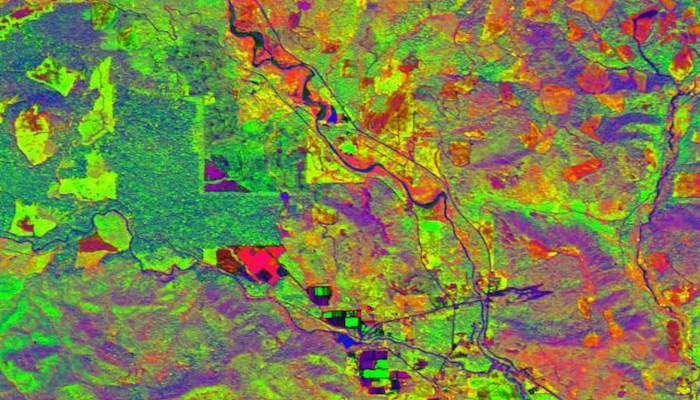
Ustin and her team use AVIRIS hyperspectral data to assess forest structure and composition. This image from the Gifford Pinchot National Forest in Washington shows an old-growth mixed conifer forest with recent logging and clear-cut patches. Red shows soil, green shows vegetation, and blue is shade. (S. Ustin, And A. Trabucco, UC Davis)
Environmental science from the sky
Ustin wears several hats at UC Davis. She is a distinguished professor of environmental and resource sciences and the vice chair for the hydrology section in the Department of Land, Air and Water Resources. She is the director of the Center for Spatial Technology and Remote Sensing (CSTARS), a remote sensing lab. (If you’ve ever wondered about the satellite receiving dish on the roof of Academic Surge or the geostationary dish on Kemper Hall, those belong to CSTARS.) She’s the associate director of research for the John Muir Institute of the Environment.
This year she was named a fellow of the prestigious American Geophysical Union, “For pioneering work in hyperspectral remote sensing that has improved our ability to understand and manage changes in terrestrial ecosystems.”
She has an office downstairs in the John Muir Institute of the Environment, but her lab is upstairs in the renovated former beef barn, a cozy space with sloped ceilings that was once a hay loft. Most of the desks have multiple computer monitors.
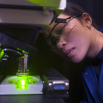
At any given time Ustin’s lab has a mixture of postdocs, undergraduates, international visitors and staff. Today several postdocs students are looking at images. What’s on the screen looks like what you’d see on Google satellite, California from the air, with different-colored gray squares and light-colored rectangles of the human-built environment — crops, housing developments, towns — and the occasional dark, curving shape of a river or a reservoir.
Within those images, though, lie layers and layers of data that they use for studying a wide variety of projects. Over the years, Ustin and her lab have assessed remote sensing data from five continents for a wide variety of environmental issues.
One of her lab’s current projects is monitoring invasive plant species in the California Delta. Another is tracking how forests that have been managed — by thinning or controlled burns — compare to untouched areas. “We ask questions like, is there evidence that the forest is healthier?” Ustin says. “Is there a difference if the control burn was 20 years ago versus five years ago? We are trying to figure out if any management techniques have resulted in a healthier forest than the uncontrolled surrounding forest.”
Being able to manage the data from remote sensing has changed considerably since Ustin first started. In the 1980s, she describes how they used “homemade” computers and “homemade” software because nothing existed to process the data.
Susan Ustin looks at remote-sensing data in her lab at The Barn. A Google Scholar search for her work reveals almost 300 titles. She has published 130 scientific proceedings and written 34 book chapters. This year she was named a fellow of the prestigious American Geophysical Union.
But now, she notes, ordinary computers can process the data, and there is a wide variety of graphic information systems software. Although she uses a lot of raw data, she notes many researchers who work in focused areas use data that has already been processed.
“NASA processes a lot of sensor data nowadays instead of giving you the raw data,” Ustin says. “For example, you can get the leaf area index for the entire world.”
What humans can see with their eyes is only a small portion of what sophisticated sensors can “see.” The visible spectrum — the portion of the electromagnetic spectrum visible to the human eye — is made up of wavelengths from about 390 nanometers (what we see as violet) up to about 700 nanometers (what we see as red). But sophisticated sensors can see a much wider range of the electromagnetic spectrum, and that data can reveal a tremendous amount of information.
The data from the NASA satellites Ustin worked with in the 1980s, like the Landsat 3, used sensors that looked at just four areas of the spectrum — green, red and two different bands of infrared. Data from each band was collected for each pixel of the image. As technology improved, sensors continued to improve and are now able to pick up more and more spectral bands and create more data for smaller and smaller areas of the image, resulting in more fine-grained information. “Now the data we are working with has close to 500 bands per pixel,” Ustin says. The data can reveal everything from how well a crop is growing or where an invasive species is taking over an ecosystem to how fast a glacier is melting.
Ustin’s work with this data, with remote sensing, has resulted in a tremendous amount of research. She has published 130 scientific proceedings and written 34 book chapters. She estimates she’s published over 200 articles in peer-reviewed journals. A Google Scholar search for her work reveals almost 300, with subjects in remote sensing, environmental sciences, geography, geology, vegetation, canopies and more. Her journal articles have titles like, “Marsh Loss Due to Cumulative Impacts of Hurricane Isaac and the Deepwater Horizon Oil Spill in Louisiana,” and “Remote sensing of canopy chemistry.”
Her most cited article, with 824 citations, is from the January 1990 edition of Remote Sensing of Environment: “Vegetation in the deserts: 1. A regional measure of abundance from multispectral images.” The paper grew out of fieldwork she did in Owens Valley in the mid-1980s. It remains one of her favorite research projects.
“It was pretty fun.” Ustin laughs. She and her fellow researchers stayed at the University of California’s White Mountain Research Center, in Bishop. They were there to map the amount of vegetation compared to the data from NASA’s Landsat-5 satellite.
In the paper, they describe taking a method of analysis used by geologists and chemists, and applied it to remote sensing data. “We were trying to map the amount of vegetation,” Ustin says. “Mixture analysis was being used in totally different contexts, but it was the same general idea. You have a solution that’s a mixture of things, so how do you tell what’s in it?”
Applying the new method worked. “It was pretty cool,” Ustin says. “We were able to estimate the vegetation cover fraction across the valley, from the valley floor up into the east side of the Sierras.” Their method ended up becoming a standard analysis in the field.
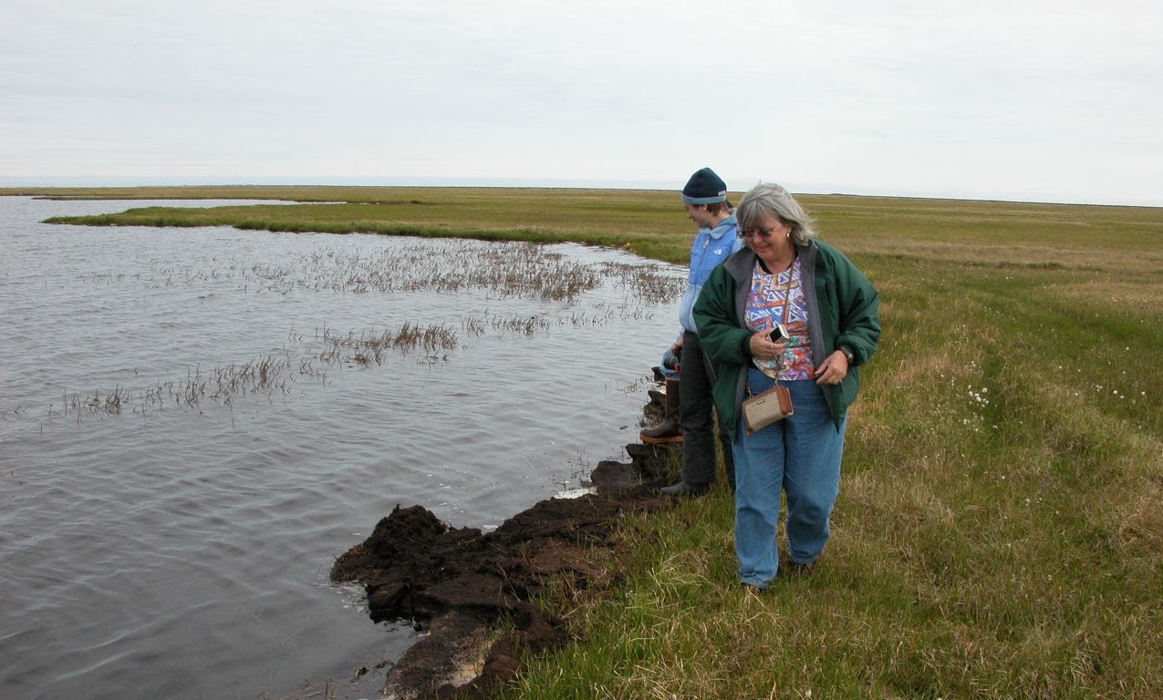
Susan Ustin in Northslope near Barrow Alaska, 2007. She was there for a graduate student research project looking at the carbon fluxes that happen when the lakes drain.
Career shaped by 1960s culture and counterculture
Ustin is originally from Eugene, Oregon. In 1961, after graduating from high school, she moved to San Francisco with friends.
This was few years after the peak of the Beat Generation in San Francisco, but North Beach was still a hangout for writers, artists and musicians. “You could go to coffee shops and they still had the sort of Beat stuff, and of course there was City Lights Bookstore,” Ustin says.
She was drawn to the city’s vibrancy and activism. Integration was happening all over the country, and in San Francisco there were civil rights marches and demonstrations, as well as picketing of businesses — hotels, restaurants, car dealerships — that refused the hire African Americans.
In the 1960s, there was also a growing awareness of the environmental damage happening to the planet. “People were worried about environmental degradation. Rachel Carson’s Silent Spring had come out,” Ustin says, referring to the landmark environmental book that called attention to the detrimental effects of pesticides like DDT, “and in the Bay Area there were a couple of oil spills that did a lot of damage to wildlife and birds.”
She worked downtown, at the Emporium department store on Market Street. She married and had two sons. “I had a lot of friends. It was fun and exciting. Then came the Summer of Love,” Ustin says, talking about the hippy countercultural phenomenon that attracted an estimated 100,000 mostly young people to San Francisco’s Haight Ashbury district. “My husband thought it would be really fun to go off and be a hippy. We had two kids. So that’s when I decided to go back to school.”
Ustin followed her interest in environmental issues and received a B.S. in biological sciences in 1974 and an M.S. in biological sciences in 1977, both from California State University Hayward. As a single mother, she notes she was able to attend because of Great Society programs that helped her financially and with childcare. Later on, she also received financial help that allowed her to pursue her Ph.D. at UC Davis. “At that time, California had state scholarships for graduate students. I got one of those and so I could attend,” Ustin says. In 1982, she married James Doyle, now a professor emeritus in the Department of Evolution and Ecology, and had her third son the following year.
Ustin was studying plant physiological ecology — how plants respond to physical stresses — and in 1982, the year before she received her Ph.D. in botany, she began working with the Jet Propulsion Lab.
“They were looking for someone who knew about plants and photosynthesis and how plants responded to environmental conditions for their new remote sensing program,” Ustin says. “At that point, remote sensing was very new and the people involved were usually from engineering or geology. They were looking for environmental ecologists, since most of the land is covered with plants and that’s what you see most of the time,” she says.
And with that, she was hooked on remote sensing.
A different perspective
Ustin has no plans to retire, as of yet, although she admits she does less fieldwork than she used to. She laughs. “Now I send other people to do it.”
One of the things she likes about what she does is that she doesn’t do the same thing every day. With every new project, there are new problems to solve.
A major project Ustin is working on now is securing funding for collaboration with the Jet Propulsion Lab to launch a big data platform — an airplane that can collect data — with the most modern imaging technology available. The concept for this new airborne sensor system is that it will be dedicated to monitoring California agriculture and ecosystems, and therefore available when it is needed.
She’s also looking for simpler new ways to collect remote sensing data at much lower altitudes, which explains the new drone sitting in a box in the corner of her office.
“I have students that would like to fly them and I thought we would do a project at Russell Ranch,” the university’s 300-acre agricultural research facility just a few miles from the main campus.
She sees new technology, like drones, being big game changers. “Instead of having to rely on a company or a government program, it suddenly puts the technology in everybody’s hands. You can collect the data yourself and have a lot more flexibility,” Ustin says. For example, not just relying on when the satellite comes over.
She notes the camera in the drone she bought for her students isn’t particularly good, but that they could probably work with someone in Department of Engineering to build a sensor. Or they may use one of the new hyperspectral cameras that have many infrared bands. Or maybe a LIDAR device, a remote sensing method that uses light in the form of a pulsed laser. “There are lots of possibilities,” she says.
“A lot of the farmers in the valley are starting to fly drones and they’re not doing complicated image analysis. They’re just looking at the spatial patterns. They’ll notice, yes, that part in that field — that’s where it’s really sandy and drains too fast. Or that part has too much clay and it doesn’t drain. Half the time, when they see it, they recognize what the problem is.”
And this, to some extent, sums up why Ustin’s work is so significant.
Remote sensing is not simply about collecting data from the air. It’s how seeing the data — seeing the world from above — helps people recognize what is happening. Problems can be identified and potentially mitigated or managed, everything from deforestation, excess nitrogen runoff, ecosystem degradation, dying forests, poor irrigation, invasive species and more.
Environmental degradation still concerns her. “Temperatures are increasing. Glaciers all over the world are declining. Snow packs are declining. Precipitation in the Western United States has been declining for 30 years or more. All of these changes are going to have an impact on us,” she says.
But to see the problems, it helps to look from above, whether from a few hundred feet up in the air with a drone or 23 miles above the Earth with a satellite.
“We are too close, from our scale,” Ustin says. “Remote sensing gives you a different perspective. It’s easier to see the problems.”
Contacts
- Lisa Howard, UC Davis Office of Research, [email protected]
- Susan L. Ustin, Department of Land, Air and Water Resources, [email protected]
Resources
- Center for Spatial Technologies and Remote Sensing
- Remote Sensing Pioneer: Professor Susan Ustin Named fellow of American Geophysical Union
- Experts on Gulf Oil SpillHandling Satellite Data in Real Time
- A Window on the Environment From Tahoe to the Ocean
- UC Davis Wins $3.8 Million for Biocomplexity Study
Latest News & Events